

Orinda, CA Real Estate Agent
Neighborhoods, Schools & Hillside Lots, Explained
About Orinda
How Do Orinda’s Neighborhoods Differ?
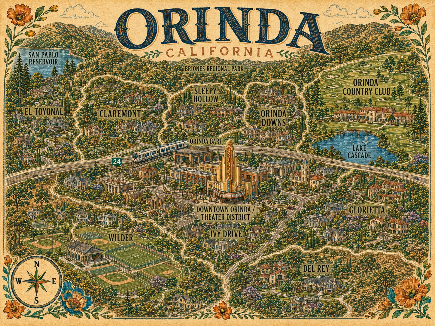
Highway 24 splits Orinda, and the two halves don’t read alike. North of it: Sleepy Hollow’s wooded seclusion, Orinda Downs’ flatter ground and larger homes, and the country club neighborhood around Lake Cascade. South of it: Ivy Drive within walking distance of BART, flat Glorietta, and Wilder, the newest, a planned subdivision ringed by open space. Amanda Velez is an Orinda real estate agent and REALTOR® with Abio Properties.
North of the freeway, Sleepy Hollow is the secluded one — a wooded valley off Camino Pablo and Miner Road with large lots, its own elementary school, and a swim and tennis club — with Orinda Downs beside it on flatter ground, wide streets, and some of the largest homes in the area. The Orinda Country Club neighborhood wraps a private club dating to 1924, its golf course, and Lake Cascade, in Spanish, Mediterranean, and ranch homes. El Toyonal and Claremont climb the hillsides to the west with a more rural feel. South of the freeway, Glorietta is the flat pocket around Glorietta Elementary and the Meadow Swim & Tennis Club; Del Rey sits at the southern end toward Moraga; Ivy Drive is the most in-town of them, walkable to downtown and BART; and Wilder, in Gateway Valley, is the newest — a 245-lot planned subdivision ringed by more than 1,300 acres of preserved open space, with a clubhouse, pool, and fitness facility.
Mid-century modern and California ranch dominate, particularly in Ivy Drive, Del Rey, and Sleepy Hollow, and the city’s landmark list includes a Frank Lloyd Wright house and a Richard Neutra house. Roughly nine in ten Orinda homes are detached single-family, the most concentrated detached profile in Lamorinda, and the zoning runs across nine residential districts from six-thousand-square-foot lots up to ten-acre minimums. Two things tend to surprise buyers. How much house you can build is capped on a sliding scale tied to lot size, with added design review above certain sizes and a slope formula that raises the minimum lot size on steeper ground. And HOA status varies sharply by neighborhood — Wilder is governed in detail, Orinda Downs has its own association, and most established neighborhoods have little beyond a small neighborhood group, so it is worth confirming per listing rather than assuming.
Being the first city east of the Caldecott Tunnel puts Orinda about as close to San Francisco as Contra Costa County gets. Orinda BART sits on the Yellow Line, and the ride to downtown San Francisco is commonly put at twenty-five to thirty minutes, with Oakland closer to fifteen or twenty. The station works as a park-and-ride — most riders drive to it and only about one in ten walks — which is part of why the in-town pockets near downtown hold their own appeal. Driving west, the Caldecott and the Bay Bridge are the variables, so treat any drive time as a range rather than a number.
Orinda Union School District covers transitional kindergarten through eighth grade with four elementary schools — Del Rey, Glorietta, Sleepy Hollow, and Wagner Ranch — all feeding the single Orinda Intermediate School. Elementary assignment is address-based and the district publishes an official lookup tool; note too that the OUSD boundary takes in small portions of Lafayette and Moraga. High school falls to the Acalanes Union High School District, and unlike Lafayette, whose students split between Acalanes and Las Lomas depending on address, Orinda addresses feed Miramonte High School on Moraga Way. The Acalanes boundary reaches well past Orinda, so confirm the exact address with the district rather than relying on a district-wide statement.
The 1941 Orinda Theatre is the city’s landmark — a Streamline Moderne house slated for demolition in 1984, saved by residents, reopened in 1989, and now on the National Register as the anchor of Theatre Square. Downtown is really two nodes split by the freeway: Theatre Square on the north side, and Orinda Village and Crossroads on the south with the library and post office. Outside those two pockets Orinda is a car city, hilly and spread out and not built for walking, which is the trade-off for the setting. The open space more than answers for it — Briones Regional Park, the EBMUD trail system, the De La Veaga Trail connecting downtown to Tilden, and the long Briones Reservoir loop. One clarification worth making early, because it comes up: Lake Cascade is private, inside the country club property. Lot size, slope, and HOA status all move an Orinda number. Amanda’s White Glove process accounts for each of them, alongside a comparable market analysis built on real Orinda sales, a vetted network of local vendors, and clear communication from first conversation through closing.
Explore the Map
Orinda Neighborhoods, Pinned
Nearby Communities
Also Serving
Common Questions
Orinda Real Estate: Common Questions
How long is the BART ride from Orinda to San Francisco?
Commonly put at twenty-five to thirty minutes to downtown San Francisco, with Oakland closer to fifteen or twenty. Orinda is the first city east of the Caldecott Tunnel.
Do Orinda homes have HOAs?
It varies sharply by neighborhood. Wilder is governed in detail and Orinda Downs has its own association, while most established neighborhoods have little beyond a small neighborhood group — worth confirming per listing rather than assuming.
Which high school do Orinda students attend?
All Orinda addresses feed Miramonte High School on Moraga Way, unlike Lafayette, whose students split between Acalanes and Las Lomas depending on address. Confirm the exact address with the Acalanes Union High School District.