
Concord, CA Real Estate Agent
Neighborhoods, Schools & BART, Explained
About Concord
How Do Concord’s Neighborhoods Differ?
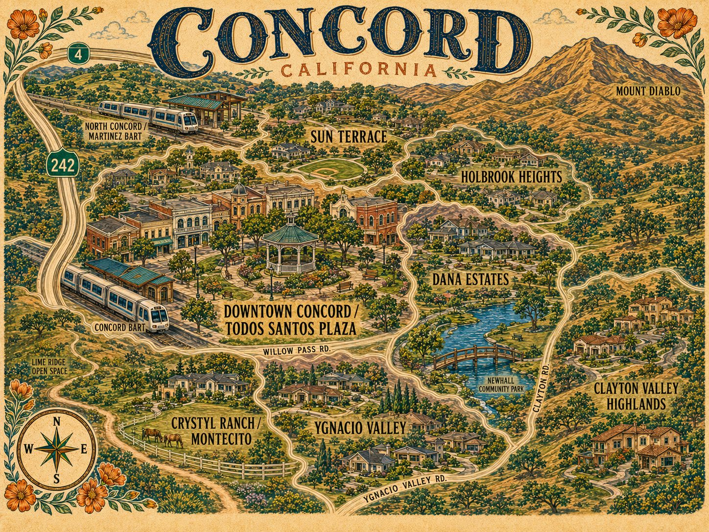
Concord’s neighborhoods split by era more than by geography: Crystyl Ranch and Montecito are late-1990s and 2000s executive pockets in the Mount Diablo foothills with active HOAs, Holbrook Heights and Sun Terrace are 1940s-to-1960s ranch and bungalow streets near North Concord BART, and Ygnacio Valley runs 1960s through 1990s on tree-lined streets. Amanda Velez is a Concord real estate agent and REALTOR® with Abio Properties, working Crystyl Ranch, Dana Estates, Ygnacio Valley and downtown.
Crystyl Ranch — often spelled Crystal Ranch, so it is worth searching both ways — and neighboring Montecito are the newer executive-home pockets in the Mount Diablo foothills toward Walnut Creek and Clayton, built from the late 1990s through the 2000s with larger square footage and active HOAs. Holbrook Heights north of downtown is 1940s-to-1960s ranches and bungalows within walking distance of North Concord BART. Dana Estates is a tight-knit central neighborhood of mid-century ranches with its own resident alliance. Ygnacio Valley runs to ranch and contemporary homes from the 1960s through the 1990s on tree-lined streets, with condominium complexes at its northeast end. Clayton Valley Highlands sits at the city’s edge near Mount Diablo State Park with larger yards, Sun Terrace is 1960s ranch tract housing close to North Concord BART and Highway 242, and downtown around Todos Santos Plaza mixes older homes with newer mixed-use apartments.
The dominant type across the established neighborhoods is the single-story ranch from the 1950s through the 1970s, generally on lots between roughly five and twelve thousand square feet. New construction is limited citywide, so most of what trades is existing stock. HOAs are common in the newer subdivisions and in condominium and townhome complexes, while the older established single-family neighborhoods are largely without one.
Two BART stations serve Concord — Concord station on Oakland Avenue and North Concord/Martinez on Port Chicago Highway, both on the Yellow Line. Despite the name, North Concord/Martinez is physically in Concord, and it is the closest station for Martinez residents as well. Commonly reported times put downtown San Francisco somewhere around forty-five to fifty minutes by BART, Oakland in the mid-thirties, and Walnut Creek about twelve minutes from the north station. Interstate 680 runs north to south through the city and Highway 242 connects it to Highway 4. The I-680 and 242 junction and Clayton Road are the local chokepoints at peak, so treat any drive time as a range.
Schools are simpler here than in most of the surrounding cities. Concord sits almost entirely inside the Mt. Diablo Unified School District, which covers roughly 150 square miles — all of Concord and Clayton, most of Pleasant Hill, and portions of Walnut Creek, Martinez, Pittsburg, and Lafayette. High schools serving Concord addresses include Concord High, Mt. Diablo High, and Ygnacio Valley High, with Northgate High near the Walnut Creek border and College Park High near Pleasant Hill each serving parts of the city, plus the independently chartered Clayton Valley Charter High. District lines do not follow city limits and can split individual streets, so confirm the exact address through the district’s school locator rather than assuming from the neighborhood.
Todos Santos Plaza is the center of civic life downtown, with a year-round Tuesday farmers market, a summer Thursday concert series that has run for more than three decades, the Fourth of July parade, and the holiday tree lighting. Downtown came through a major streetscape and mixed-use rebuild and now carries more dining and housing than it did a decade ago. Beyond it, Lime Ridge, Newhall, and Hillcrest are the large parks, the Iron Horse and Canal trails run through the city for walking and cycling, and Mount Diablo State Park is close enough to be a regular weekend rather than a trip. One honest trade-off worth naming: Concord is among the hottest parts of the Bay Area in summer, with the occasional winter frost. Concord’s neighborhoods price differently by era, so the comparables matter more here than the citywide average. Amanda’s White Glove process starts with a market analysis built on real Concord sales, plus a vetted network of local vendors and clear communication through closing.
Explore the Map
Concord Neighborhoods, Pinned
Nearby Communities
Also Serving
Common Questions
Concord Real Estate: Common Questions
How many BART stations does Concord have?
Two — Concord station on Oakland Avenue and North Concord/Martinez on Port Chicago Highway, both on the Yellow Line. Despite the name, North Concord/Martinez is physically in Concord.
Which school district serves Concord?
Concord sits almost entirely inside the Mt. Diablo Unified School District. High schools serving Concord addresses include Concord, Mt. Diablo and Ygnacio Valley, with Northgate near the Walnut Creek border and College Park near Pleasant Hill each serving parts of the city. District lines do not follow city limits, so confirm the exact address.
Is it Crystyl Ranch or Crystal Ranch?
Both spellings are in common use for the same neighborhood, so it is worth searching either way when you are looking at listings.